 |
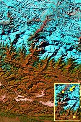
Satellite View of the area around the Gandaki River.
This satellite view of the area
around the Gandaki river
is acquired over the Himalayan Mountains in January, 1989, by Landsat
Thematic Mapper
Annapurna
Trekking Circuit
The picture includes the Annapurna Trekking Circuit. As reference
points the arrow in the insert above points to Muktinath-Chumig
Gyatsa. The top yellow square marks Jomsom; the square at the
right below, Pokhara.
Colors
Regarding the colors in the picture: snow and ice appear blue while
vegetation is green, rocks are red, and clouds are white.
 Back to your previous page
Annapurna
- Muktinath
Map - Muktinath
History -
Muktinath Lama Wangyal - Travel
Info - Nuns
- Picture
Gallery - Site
Map- MFI
Recommendations - Support
us with a donation

|
 |