|
Maps
mentioning Salagrama
Within
Hindu religion Salagrama
is considered the most holy spot connected to the Gandaki
River and the veneration of Salagrama
stones. Various Hindu schools have
different opinions regarding the exact location of the spot, but all
agree Salagrama
is connected to the Gandaki River, just a few
hours walking from Muktinath-Chumig Gyatsa.
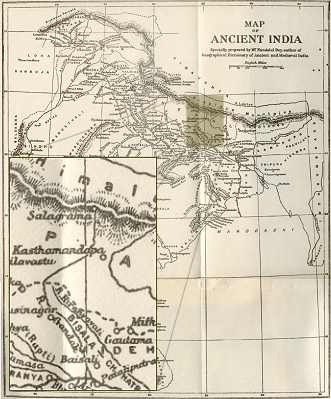
On this page two maps locating Salagrama on different spots.
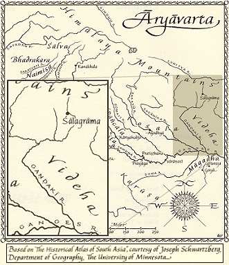
The
location of Salagrama
as mentioned on the above map can be found in the most recent English
translation of The Mahabharata.* The map below can be found
in The Geograhical Dictionary of Ancient and Medieval India.*
The course of the Gandaki on both maps does not correspond with the
actual course, but it is clear that according to the map below
Salagrama
is at the source of the Gandaki River just near the boarder with Tibet,**
while the map above locates Salagrama
about 60-70 miles below the source of the Gandaki.
Both maps connect Salagrama
with the Gandaki River
as can be found in the Purana
legends. See also Tirtha-pratyamnayah.
* (see
reference page)
** In his book Mustang, A Lost Tibetan Kingdom (Book Faith
India, Delhi-1992) author Michel Peissel mentions on page 215 he visited
the source of the Gandaki River. He located the source near the boarder
of Tibet at the village Namdrol, in Mustang, Nepal.
( back to top) back to top)
Annapurna
- Muktinath
Map - Muktinath
History -
Muktinath Lama Wangyal - Travel
Info - Nuns
- Picture
Gallery - Site
Map- MFI
Recommendations
Support
us with a donation
|